Get In Touch
Get in touch with us for any questions or quotes on surveying services and products. We will respond back as soon as we can.

Founded in 2005, Zupt began with a clear mission: to improve the accuracy, safety, and environmental impact of navigation and positioning systems used in complex survey operations. Starting in the onshore seismic industry, our team was frustrated by the time-consuming and disruptive nature of traditional land survey methods.
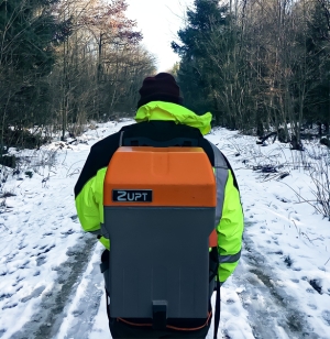
To solve this, we introduced A-PINS, a two-person inertial navigation system that drastically improved efficiency over traditional methodologies in GNSS denied areas. This then led to the creation of B-PINS, a backpack-portable inertial navigation system designed for safer and more efficient data acquisition. B-PINS has since been deployed worldwide, surveying tens of thousands of kilometers in remote, difficult environments.
Building on this success, we expanded our focus to the offshore energy industry, specifically to subsea metrology operations. Our goal remained the same: streamline survey operations, improve precision, and reduce time offshore. We developed advanced inertial subsea metrology solutions that have saved thousands of vessel hours and significantly lowered the carbon footprint of offshore construction and inspection projects.
Today, Zupt continues to innovate across the offshore energy sector, including remote metrology, subsea 3D modeling, and offshore wind monopile positioning in support of the renewables industry. We specialize in integrating inertial navigation, robotic total stations, and sensor fusion technologies to deliver accurate, reliable data with reduced offshore risk.
All of our key technologies are developed in-house by a highly experienced engineering and operations team. From early field deployment to fully remote autonomous solutions, we focus on making complex technology easy to use and delivering results faster than traditional methods.
Zupt remains a nimble, independent company trusted by global leaders in offshore energy, marine construction, and subsea inspection. Our technology helps clients reduce vessel time, improve accuracy, and operate more sustainably.
Q: Do you sell products or services?
A: We offer both. Zupt provides offshore services with skilled personnel and specialized equipment for a variety of offshore marine construction survey projects. We also exclusively sell certain offshore products, such as Fusion Splice and MicroTTU. However, some of the sensors used in our services, like those involved in jumper metrology with our C-PINS inertial navigation system, are not available for direct sale. These are operated only by Zupt-trained personnel to deliver accurate, certified data to our clients.
Q: Where do you work?
A: Zupt works worldwide! We have local content partners worldwide with a heavy presence in West Africa and the UK. We have performed marine construction survey work in the Gulf of Mexico, the North Sea, West Africa (Ghana, Congo, Nigeria, Angola), Australia, South America, Bahamas, and more. We work off of survey vessels, platforms, or rigs.
Q: What industries does Zupt serve?
A: Zupt supports a range of industries including offshore energy for both oil and gas and renewables, marine construction, subsea inspection, and infrastructure projects that require precise metrology and positioning solutions.
Q: What makes Zupt’s technology different?
A: All of Zupt’s core inertial navigation and metrology technologies are developed in-house. This approach allows us to innovate continuously and deliver highly reliable, customized solutions that simplify complex offshore operations.
Q: How do you ensure safety during offshore operations?
A: Safety is a top priority at Zupt. We strictly adhere to industry safety standards, provide thorough training for all personnel, and regularly review and improve our procedures to ensure the well-being of our team and clients throughout every project.
Q: Can Zupt provide turnkey survey solutions?
A: Yes. Zupt offers comprehensive turnkey solutions that include skilled personnel, specialized equipment, data processing, and detailed deliverables tailored to meet the unique requirements of each project.
Q: How quickly can Zupt mobilize for a project?
A: Thanks to our experienced team and strong global partnerships, Zupt can mobilize rapidly to meet project schedules, often providing personnel and equipment on short notice to support urgent operational needs.
Zupt, LLC is certified to the ISO 9001:2015 Quality Management System standard for the design, manufacture, sales, rental, operation, and repair of inertial positioning systems.
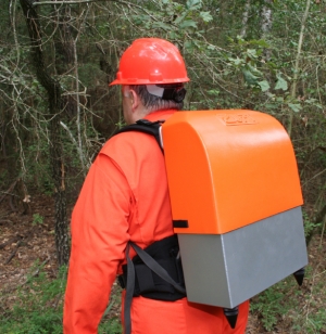
B-PINS is a precise survey tool designed to provide accurate navigation in GNSS denied areas with four times the productivity of traditional survey methods. B-PINS employs proven inertial navigation technology to provide a portable and accurate survey solution under dense canopy or urban canyon situations. The high-performance inertial sensors integrated into B-PINS deliver proven positioning accuracy significantly better than survey tolerances accepted by the international seismic acquisition community.
Contact Zupt today to learn more.
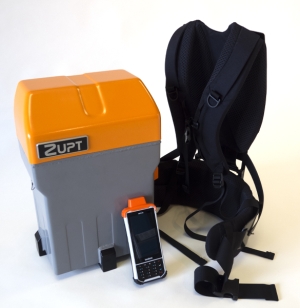
The B-PINS X is Zupt’s next generation land inertial survey system, designed for environments where GPS signals are weak, inconsistent, or completely unavailable. It delivers survey-grade accuracy through advanced inertial navigation methods, enabling reliable positioning in areas such as forests, urban canyons, or regions with heavy overhead cover. Building on the proven capabilities of earlier B-PINS systems, the B-PINS X gives surveyors a dependable solution when GNSS cannot perform.
Key upgrades include a smaller, lighter design, extended battery life with hot-swappable batteries, and integration with a handheld controller and laser range finder for efficient data collection. The system is engineered to withstand a wide range of field conditions, maintaining performance across challenging terrains and weather extremes.
These enhancements make B-PINS X a powerful tool for maximizing productivity and ensuring accurate survey results in demanding environments. Its portability reduces operational costs, while its precision opens opportunities to work in places once impractical for traditional survey methods.
Contact Zupt today to learn more.
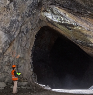
In areas with absolutely no access to GNSS signals, B-PINS is an ideal survey tool to accurately map or navigate through underground areas. B-PINS can be carried by surveyor/vehicle deep into underground mines to survey and plot a path in real-world 3D coordinates.
Contact Zupt today to learn more.
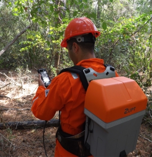
Surveys completed with the B-PINS system enable surveys to be completed in environmentally sensitive areas such as in dense forests. Because our method does not require a clear line of sight through the woods, it poses a minimal threat to trees and vegetation. The B-PINS system provides accuracy, high levels of survey productivity, with very low to no environmental impact.
Contact Zupt today to learn more.
Zupt’s B-PINS deliver precise stakeout locations in harsh environments during pipeline right of way where conventional survey methods are inefficient or ineffective. Field testing by pipeline stakeout professionals determined B-PINS is the choice for getting the job done accurately and productively at the lowest cost. A surveyor simply calibrates the B-PINS, walks the pre-determined pipeline route, processes, and adjusts the data, and imports it into a modeling package for precise horizontal and vertical coordinates of the terrain.
Contact Zupt today to learn more.
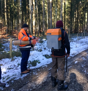
Zupt’s inertial solution, B-PINS, allows survey operations with minimal cutting while significantly increasing the production of field survey crews. During land seismic exploration, tree canopy often permits GNSS use for precise placement of survey stakes. Signals from the satellite segment of GNSS systems cannot penetrate through the tree canopy. Optical survey techniques can be used when the tree canopy or terrain limits GNSS operations, but it requires extensive cutting for a clear line of sight to operate. This cutting takes a significant amount of time and can have detrimental effects on the environment in the surveyed areas. One inertial survey crew using B-PINS can deliver the production of several conventional crews with post-survey processing results equal or better than GNSS surveys.
Contact Zupt today to learn more.
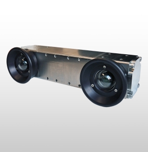
HaloCAM is a compact, 4000-meter rated sensor that delivers precise pitch, roll, heading, depth, and position for subsea structures during installation. It reduces the cost and risk of attaching expensive sensors directly to piles, conductors, or other subsea structures while ensuring accurate deployment and long-term reliability.
Inside its single 266mm x 150mm housing, HaloCAM combines an Inertial Navigation System (INS), a machine vision camera, and onboard processing. This integration provides real-time positioning and attitude data through a straightforward user interface, and the navigation engine can accept inputs from USBL, LBL, DVL, depth, or LoPs, making the system adaptable to a wide range of offshore projects. HaloCAM’s design allows it to be easily deployed on an ROV, delivering accurate updates even in challenging conditions.
By combining inertial navigation with machine vision, HaloCAM offers a reliable and efficient solution that improves safety, reduces operational costs, and enhances confidence across both oil and gas and offshore wind projects.
HaloCAM combines a high-performance IMU with an HD camera and onboard machine vision processing to deliver the positioning accuracy the industry requires.
Mounted on the front of an ROV, HaloCAM maintains a clear line of sight to simple fiducial targets placed on the structure. The system automatically acquires the targets, processes INS and camera data internally, and provides real-time position and attitude through an intuitive user interface. The ROV can maintain a 2–4 meter standoff while HaloCAM delivers consistent updates unaffected by vibration, hammering, or jetting during installation. Targets can be dimensionally controlled and placed on flat or curved surfaces.
If the ROV has absolute positioning (USBL, LBL, or LoPs), HaloCAM translates this reference frame to the structure with the same accuracy. When not used for structure positioning, HaloCAM functions as a precise subsea INS.
Contact Zupt today to learn more.
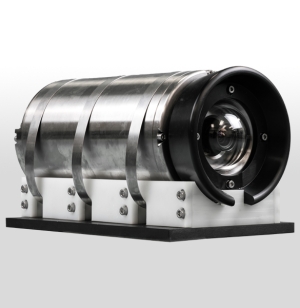
3D Recon V2 is a subsea stereo imaging system that produces high-resolution, geospatially accurate 3D models of what is seen subsea. Housed in a compact subsea enclosure rated for depths up to 4,000 meters, it features two high-resolution machine vision cameras and a high-performance MEMS IMU. By integrating inertial technology with imaging sensors, 3D Recon V2 can generate real-time sparse point clouds for navigation and quality control, as well as high-density 3D models that help engineers make informed decisions about the integrity of their subsea assets.
While 3D Recon V2 was initially developed for Integrity Management (IM) and Inspection, Repair, and Maintenance (IRM) purposes. Its versatility has since led to adoption in a range of other applications, including::
3D Recon V2 leverages 3D reconstruction and photogrammetry methodologies, advanced computer vision, and inertial navigation techniques to generate accurate camera poses and high-resolution point clouds of subsea assets. It supports both real-time reconstruction and highly optimized offline dense point cloud generation. Here's how each pipeline works:
Real-Time Dense Point Cloud:
Offline Dense Point Cloud:
Real-Time Detection and Pose Estimation of Underwater Objects:
3D Recon V2 delivers high-resolution, geospatially accurate 3D models with submillimeter pixel resolution. These precise models support the subsea integrity community in making informed decisions about structural health over time. 3D Recon V2 integrates seamlessly into existing workflows, providing high-resolution still images, conventional video, and 3D models generated both in real time for verification and offline for detailed inspection.
We require a survey mux to integrate the 3D Recon V2 spread. All power, serial communications, and image data are connected to the Mux/ROV through a single PBOF cable. It relies on one RS232 and one GB Ethernet port for configuration and data transmission. Power requirements are 24Vdc at 150W.
Contact Zupt today to learn more about 3D Recon V2 and how it can enhance your subsea operations.
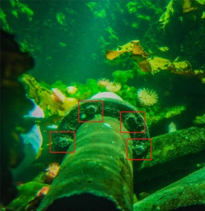
Zupt’s asset identification solutions are trained to identify certain object in practical subsea scenarios. Zupt develops and deploys software solutions that utilize Tensorflow and Yolov4 for object identification. Remove additional personnel offshore by introducing artificial intelligence packages to detect and identify assets automatically available as either topside units that utilize existing ROV cameras or complete sensor packages.
Contact Zupt today to learn more.